
|
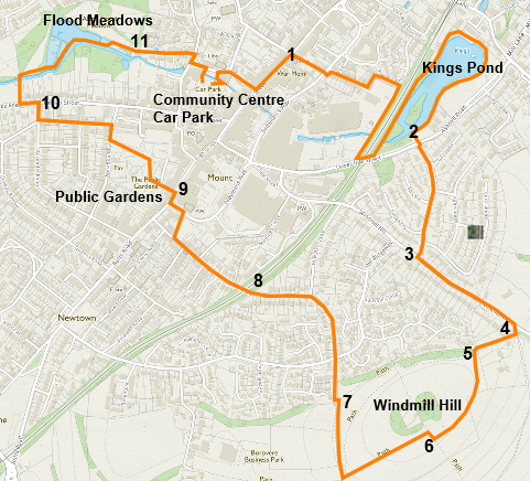
James Willis has created this walk to showcase Alton's open spaces, wonderful views, and wildlife. It is just over 3 miles long and is mainly on standard footpaths. There is a gpx file of the walk in the Walks & Routes>Routes Library in this website. Alton Town Council has further information on the town's open spaces. |
||
 |
||
|
A convenient starting point is the Community Centre car park. Go right in front of the Library and take Bakers Alley (marked Wey Walk) straight ahead through to the High Street. Now go left up Crown Hill (notice the blue plaque on No 10 – Jane Austen’s brother’s bank). On the far side of the Curtis Museum at the top, [1] go right into Mechanics Alley. This route takes you to Drayman’s Way, which you cross with due caution. The footpath opposite curves left and takes you to the top of Kingsmead, where you turn right and proceed boldly to the bottom. At the bottom, you will discover a hidden footpath going left, beyond the last house. Follow this around a right-hand corner and down to the footpath along the near side of the heavily wooded Watercress Line railway embankment. Turn right onto this path (i.e., away from the station) and walk 400 yards to Lower Turk Street, turning left under the railway bridge and then left again, back along the other side of the railway embankment (look out for steam trains) into the Kings Pond woodland. Follow clockwise around the pond – keeping close to the water and the fabulous wildlife. When you have gone about three-quarters of the way round, past a bungalow on the left, look up through the trees on your left [2] for the avenue of great Wellingtonians leading steeply up Crowley Drive. When you see this, climb the short, unmade track to Ashdell Road and cross it to the foot of this avenue. This crossing is dangerous – it is hard to see traffic coming from the right. Now climb 400 yards to the top of Crowley Drive [3] and then turn left along Windmill Lane for another, gentler 300 yards to its top. Just after the road begins to turn downhill, turn right into the open cluster of entrances [4] and take the narrow footpath half right (between two drives—second from the right). Walk on through the empty metal gate frame, and after 50 yards, turn left through the opening [5] into the public open space at Windmill Hill. Here you can walk freely, but I suggest following the mown path near the left hedge and letting it lead you round to the south (left-hand) side of the central copse. Here you can enjoy the stunning views to the south from the log seats [6]. Now carry on along the mown path past the copse and straight ahead down to the boundary hedge. Turn right along the hedge as far as the wooden litter bin [7], where steps take you left onto a sunken path. Turn immediately right down this wonderfully green, dark tunnel for some 200 yards to The Ridgeway. Go straight across, through the metal barriers, to another footpath. After another 100 yards along here, you join the top of Mount Pleasant Road. Carry straight on (avoiding the right turn at the letterbox), descend between the houses, over the Watercress Line Bridge [8], and turn right across the car park at the bottom.
Cross the road at the crossing lights and turn left in front of the Methodist Church. Cross the High Street into the road opposite past the side of the White Horse, then right at the end to reach the entrance of the Public Gardens (beyond the red brick ‘Ironing Service’ building). [9]In the Public Gardens (public toilet) bear right and walk up the avenue of pollarded lime trees past Miss Bell’s Fountain – recently restored as a water station. Turn right on the road and then left onto a narrow footpath at the prominent yellow [H] sign. At the end of this path – 200 yards – cross Ackender Road and turn right down to Lenten Street. Cross here and go left [10] 100 yards to the broad footpath, signed Wey Walk, beyond the last house. Enter Flood Meadows through the new arch and go right immediately after the footbridge, keeping close to the infant River Wey (only yards from its source). Continue along the delightful causeways maintained so lovingly by Martin Gibbs and the Alton Society volunteers. Wind along the paths in the same direction, close to the river until the way bends gently left, joins a metalled path and eventually exits in the same general direction into Tanhouse Lane [11]. That lovely little street will take you to the foot of Amery Hill where the Community Centre car park can be seen ahead of you on the right.
|